|
|
|||||||||||||||||
| Point ID: 7363 | Downloads | Plots | Site Data | Code: 70139 |
|
|
|||||||||||||||||
| Download | |
|---|---|
| Site Descriptor Information | Site Time Series Data |
| Link to all available data | |
| View: | Time Series | All |
| Units: | mm |
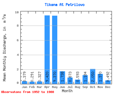
| Statistic | Jan | Feb | Mar | Apr | May | Jun | Jul | Aug | Sep | Oct | Nov | Dec | Annual |
|---|---|---|---|---|---|---|---|---|---|---|---|---|---|
| Mean | 0.38 | 0.29 | 0.33 | 9.42 | 9.37 | 1.74 | 0.87 | 0.59 | 1.18 | 2.05 | 1.37 | 0.49 | 2.31 |
| Standard Deviation | 0.20 | 0.17 | 0.19 | 5.49 | 6.02 | 1.99 | 1.06 | 0.81 | 1.71 | 2.08 | 1.29 | 0.31 | 0.65 |
| Min | 0.09 | 0.06 | 0.10 | 1.23 | 0.41 | 0.19 | 0.12 | 0.07 | 0.13 | 0.27 | 0.25 | 0.14 | 1.29 |
| Max | 0.97 | 0.81 | 1.02 | 22.10 | 23.50 | 7.55 | 3.72 | 4.33 | 6.27 | 7.93 | 5.06 | 1.50 | 3.81 |
| Coefficient of Variation | 0.52 | 0.59 | 0.58 | 0.58 | 0.64 | 1.15 | 1.21 | 1.37 | 1.45 | 1.01 | 0.94 | 0.63 | 0.28 |
 Return to R-Arctic Net Home Page