|
|
|||||||||||||||||
| Point ID: 7360 | Downloads | Plots | Site Data | Code: 70129 |
|
|
|||||||||||||||||
| Download | |
|---|---|
| Site Descriptor Information | Site Time Series Data |
| Link to all available data | |
| View: | Time Series | All |
| Units: | mm |
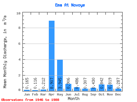
| Statistic | Jan | Feb | Mar | Apr | May | Jun | Jul | Aug | Sep | Oct | Nov | Dec | Annual |
|---|---|---|---|---|---|---|---|---|---|---|---|---|---|
| Mean | 0.17 | 0.12 | 0.21 | 8.91 | 3.94 | 0.91 | 0.49 | 0.31 | 0.43 | 0.84 | 0.82 | 0.29 | 1.45 |
| Standard Deviation | 0.17 | 0.11 | 0.26 | 3.78 | 3.40 | 1.31 | 0.73 | 0.58 | 0.69 | 0.97 | 1.10 | 0.25 | 0.45 |
| Min | 0.03 | 0.02 | 0.03 | 1.73 | 0.14 | 0.04 | 0.01 | 0.01 | 0.01 | 0.01 | 0.01 | 0.03 | 0.51 |
| Max | 0.81 | 0.62 | 1.05 | 17.80 | 12.30 | 6.06 | 3.77 | 3.41 | 3.10 | 4.05 | 5.35 | 1.05 | 2.79 |
| Coefficient of Variation | 1.01 | 0.96 | 1.22 | 0.42 | 0.86 | 1.45 | 1.50 | 1.88 | 1.62 | 1.15 | 1.34 | 0.87 | 0.31 |
 Return to R-Arctic Net Home Page