|
|
|||||||||||||||||
| Point ID: 7338 | Downloads | Plots | Site Data | Code: 70021 |
|
|
|||||||||||||||||
| Download | |
|---|---|
| Site Descriptor Information | Site Time Series Data |
| Link to all available data | |
| View: | Time Series | All |
| Units: | mm |
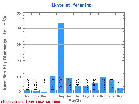
| Statistic | Jan | Feb | Mar | Apr | May | Jun | Jul | Aug | Sep | Oct | Nov | Dec | Annual |
|---|---|---|---|---|---|---|---|---|---|---|---|---|---|
| Mean | 1.56 | 1.07 | 0.87 | 10.66 | 43.34 | 9.27 | 4.48 | 3.97 | 5.91 | 9.60 | 8.14 | 3.13 | 8.42 |
| Standard Deviation | 0.71 | 0.49 | 0.36 | 10.46 | 17.41 | 5.14 | 3.34 | 3.96 | 6.00 | 7.13 | 5.55 | 2.29 | 2.39 |
| Min | 0.56 | 0.33 | 0.39 | 1.42 | 11.50 | 2.25 | 1.16 | 0.52 | 0.54 | 0.94 | 1.17 | 0.73 | 4.87 |
| Max | 3.77 | 2.08 | 1.74 | 41.00 | 93.70 | 27.70 | 14.20 | 14.70 | 25.40 | 29.40 | 18.90 | 11.30 | 14.37 |
| Coefficient of Variation | 0.46 | 0.46 | 0.41 | 0.98 | 0.40 | 0.56 | 0.75 | 1.00 | 1.02 | 0.74 | 0.68 | 0.73 | 0.28 |
 Return to R-Arctic Net Home Page