|
|
|||||||||||||||||
| Point ID: 7332 | Downloads | Plots | Site Data | Code: 49142 |
|
|
|||||||||||||||||
| Download | |
|---|---|
| Site Descriptor Information | Site Time Series Data |
| Link to all available data | |
| View: | Time Series | All |
| Units: | mm |
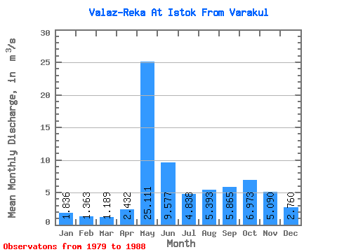
| Statistic | Jan | Feb | Mar | Apr | May | Jun | Jul | Aug | Sep | Oct | Nov | Dec | Annual |
|---|---|---|---|---|---|---|---|---|---|---|---|---|---|
| Mean | 1.84 | 1.36 | 1.19 | 2.43 | 25.11 | 9.58 | 4.84 | 5.39 | 5.87 | 6.97 | 5.09 | 2.76 | 6.08 |
| Standard Deviation | 0.66 | 0.50 | 0.30 | 2.71 | 6.38 | 4.64 | 3.27 | 3.87 | 3.07 | 2.63 | 2.26 | 1.03 | 1.43 |
| Min | 1.12 | 0.62 | 0.65 | 0.79 | 18.60 | 3.63 | 1.42 | 0.68 | 0.66 | 1.43 | 1.75 | 1.59 | 3.03 |
| Max | 2.98 | 2.07 | 1.65 | 9.30 | 37.10 | 19.40 | 11.40 | 11.90 | 11.10 | 10.20 | 8.59 | 4.23 | 7.60 |
| Coefficient of Variation | 0.36 | 0.37 | 0.26 | 1.11 | 0.25 | 0.48 | 0.68 | 0.72 | 0.52 | 0.38 | 0.44 | 0.38 | 0.23 |
 Return to R-Arctic Net Home Page