|
|
|||||||||||||||||
| Point ID: 7331 | Downloads | Plots | Site Data | Code: 49141 |
|
|
|||||||||||||||||
| Download | |
|---|---|
| Site Descriptor Information | Site Time Series Data |
| Link to all available data | |
| View: | Time Series | All |
| Units: | mm |
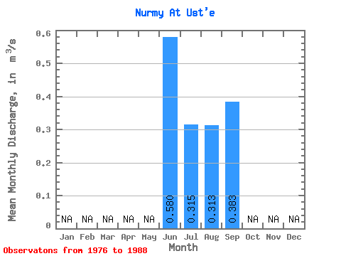
| Statistic | Jan | Feb | Mar | Apr | May | Jun | Jul | Aug | Sep | Oct | Nov | Dec | Annual |
|---|---|---|---|---|---|---|---|---|---|---|---|---|---|
| Mean | 0.58 | 0.32 | 0.31 | 0.38 | |||||||||
| Standard Deviation | 0.34 | 0.23 | 0.25 | 0.20 | |||||||||
| Min | 0.23 | 0.07 | 0.04 | 0.04 | |||||||||
| Max | 1.16 | 0.86 | 0.89 | 0.87 | |||||||||
| Coefficient of Variation | 0.59 | 0.74 | 0.79 | 0.53 |
 Return to R-Arctic Net Home Page