|
|
|||||||||||||||||
| Point ID: 7330 | Downloads | Plots | Site Data | Code: 49140 |
|
|
|||||||||||||||||
| Download | |
|---|---|
| Site Descriptor Information | Site Time Series Data |
| Link to all available data | |
| View: | Time Series | All |
| Units: | mm |
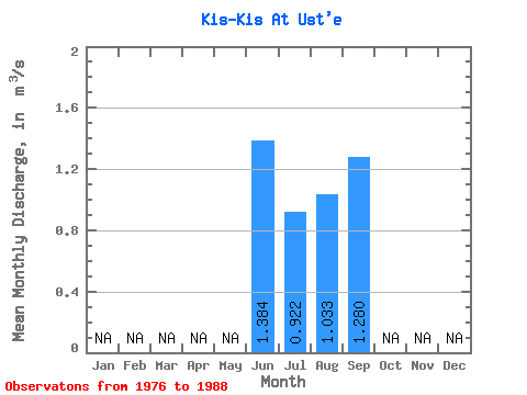
| Statistic | Jan | Feb | Mar | Apr | May | Jun | Jul | Aug | Sep | Oct | Nov | Dec | Annual |
|---|---|---|---|---|---|---|---|---|---|---|---|---|---|
| Mean | 1.38 | 0.92 | 1.03 | 1.28 | |||||||||
| Standard Deviation | 0.46 | 0.41 | 0.54 | 0.55 | |||||||||
| Min | 0.67 | 0.34 | 0.25 | 0.32 | |||||||||
| Max | 2.00 | 1.78 | 2.00 | 1.94 | |||||||||
| Coefficient of Variation | 0.34 | 0.45 | 0.52 | 0.43 |
 Return to R-Arctic Net Home Page