|
|
|||||||||||||||||
| Point ID: 733 | Downloads | Plots | Site Data | Code: 07FD011 |
|
|
|||||||||||||||||
| Download | |
|---|---|
| Site Descriptor Information | Site Time Series Data |
| Link to all available data | |
| View: | Time Series | All |
| Units: | mm |
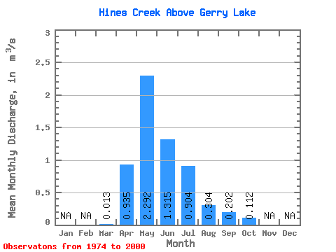
| Statistic | Jan | Feb | Mar | Apr | May | Jun | Jul | Aug | Sep | Oct | Nov | Dec | Annual |
|---|---|---|---|---|---|---|---|---|---|---|---|---|---|
| Mean | 0.01 | 0.94 | 2.29 | 1.31 | 0.90 | 0.30 | 0.20 | 0.11 | |||||
| Standard Deviation | 0.04 | 0.83 | 2.21 | 1.72 | 1.41 | 0.57 | 0.57 | 0.16 | |||||
| Min | 0.00 | 0.01 | 0.01 | 0.01 | 0.00 | 0.00 | 0.00 | 0.00 | |||||
| Max | 0.17 | 2.62 | 8.91 | 6.90 | 6.48 | 2.66 | 2.91 | 0.71 | |||||
| Coefficient of Variation | 2.61 | 0.89 | 0.96 | 1.31 | 1.56 | 1.86 | 2.81 | 1.40 |
 Return to R-Arctic Net Home Page