|
|
|||||||||||||||||
| Point ID: 7304 | Downloads | Plots | Site Data | Code: 49093 |
|
|
|||||||||||||||||
| Download | |
|---|---|
| Site Descriptor Information | Site Time Series Data |
| Link to all available data | |
| View: | Time Series | All |
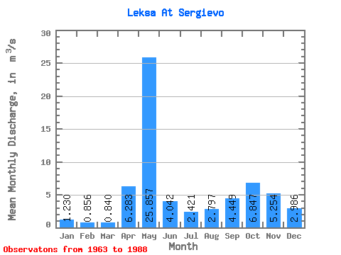
| Units: | mm |
| Statistic | Jan | Feb | Mar | Apr | May | Jun | Jul | Aug | Sep | Oct | Nov | Dec | Annual |
|---|---|---|---|---|---|---|---|---|---|---|---|---|---|
| Mean | 1.23 | 0.86 | 0.84 | 6.28 | 25.86 | 4.04 | 2.42 | 2.80 | 4.45 | 6.85 | 5.25 | 2.99 | 5.32 |
| Standard Deviation | 0.69 | 0.48 | 0.41 | 5.97 | 9.23 | 2.28 | 1.52 | 2.58 | 2.93 | 3.77 | 2.80 | 2.93 | 1.19 |
| Min | 0.36 | 0.26 | 0.10 | 0.57 | 9.17 | 1.24 | 0.88 | 0.47 | 0.79 | 1.86 | 0.77 | 0.73 | 3.79 |
| Max | 2.44 | 2.13 | 1.89 | 25.20 | 40.30 | 12.20 | 7.82 | 11.10 | 13.10 | 17.30 | 12.70 | 13.30 | 8.16 |
| Coefficient of Variation | 0.56 | 0.56 | 0.48 | 0.95 | 0.36 | 0.56 | 0.63 | 0.92 | 0.66 | 0.55 | 0.53 | 0.98 | 0.22 |
 Return to R-Arctic Net Home Page