|
|
|||||||||||||||||
| Point ID: 73 | Downloads | Plots | Site Data | Code: 05AC028 |
|
|
|||||||||||||||||
| Download | |
|---|---|
| Site Descriptor Information | Site Time Series Data |
| Link to all available data | |
| View: | Time Series | All |
| Units: | mm |
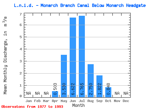
| Statistic | Jan | Feb | Mar | Apr | May | Jun | Jul | Aug | Sep | Oct | Nov | Dec | Annual |
|---|---|---|---|---|---|---|---|---|---|---|---|---|---|
| Mean | 0.50 | 3.53 | 6.62 | 6.76 | 2.75 | 1.82 | 0.85 | ||||||
| Standard Deviation | 0.60 | 2.52 | 3.37 | 2.75 | 1.11 | 1.15 | 0.56 | ||||||
| Min | 0.00 | 0.87 | 0.94 | 0.56 | 1.08 | 0.62 | 0.10 | ||||||
| Max | 1.23 | 8.47 | 11.20 | 9.46 | 4.90 | 4.60 | 1.97 | ||||||
| Coefficient of Variation | 1.20 | 0.71 | 0.51 | 0.41 | 0.40 | 0.63 | 0.66 |
 Return to R-Arctic Net Home Page