|
|
|||||||||||||||||
| Point ID: 7270 | Downloads | Plots | Site Data | Code: 49014 |
|
|
|||||||||||||||||
| Download | |
|---|---|
| Site Descriptor Information | Site Time Series Data |
| Link to all available data | |
| View: | Time Series | All |
| Units: | mm |
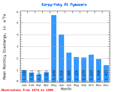
| Statistic | Jan | Feb | Mar | Apr | May | Jun | Jul | Aug | Sep | Oct | Nov | Dec | Annual |
|---|---|---|---|---|---|---|---|---|---|---|---|---|---|
| Mean | 1.03 | 0.81 | 0.67 | 0.82 | 5.65 | 4.02 | 2.48 | 2.13 | 2.08 | 2.31 | 1.95 | 1.43 | 2.07 |
| Standard Deviation | 0.38 | 0.29 | 0.17 | 0.44 | 2.08 | 1.44 | 1.08 | 1.21 | 1.13 | 1.11 | 0.89 | 0.50 | 0.49 |
| Min | 0.48 | 0.43 | 0.39 | 0.53 | 2.71 | 1.87 | 0.78 | 0.51 | 0.33 | 0.55 | 0.42 | 0.55 | 1.06 |
| Max | 1.94 | 1.64 | 1.12 | 2.15 | 10.10 | 6.76 | 4.77 | 4.43 | 3.98 | 4.68 | 4.15 | 2.11 | 2.72 |
| Coefficient of Variation | 0.37 | 0.36 | 0.26 | 0.53 | 0.37 | 0.36 | 0.43 | 0.57 | 0.54 | 0.48 | 0.46 | 0.35 | 0.23 |
 Return to R-Arctic Net Home Page