|
|
|||||||||||||||||
| Point ID: 7256 | Downloads | Plots | Site Data | Code: 12606 |
|
|
|||||||||||||||||
| Download | |
|---|---|
| Site Descriptor Information | Site Time Series Data |
| Link to all available data | |
| View: | Time Series | All |
| Units: | mm |
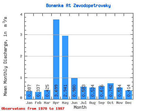
| Statistic | Jan | Feb | Mar | Apr | May | Jun | Jul | Aug | Sep | Oct | Nov | Dec | Annual |
|---|---|---|---|---|---|---|---|---|---|---|---|---|---|
| Mean | 0.39 | 0.34 | 0.42 | 3.70 | 2.94 | 0.98 | 0.58 | 0.53 | 0.62 | 0.74 | 0.53 | 0.41 | 1.00 |
| Standard Deviation | 0.12 | 0.11 | 0.11 | 1.78 | 1.89 | 0.53 | 0.26 | 0.33 | 0.32 | 0.36 | 0.14 | 0.13 | 0.34 |
| Min | 0.22 | 0.12 | 0.14 | 1.14 | 1.07 | 0.39 | 0.19 | 0.17 | 0.23 | 0.43 | 0.30 | 0.25 | 0.60 |
| Max | 0.68 | 0.52 | 0.61 | 7.61 | 7.25 | 2.32 | 1.08 | 1.57 | 1.56 | 1.92 | 0.82 | 0.76 | 1.88 |
| Coefficient of Variation | 0.30 | 0.32 | 0.27 | 0.48 | 0.64 | 0.54 | 0.45 | 0.62 | 0.52 | 0.49 | 0.25 | 0.31 | 0.34 |
 Return to R-Arctic Net Home Page