|
|
|||||||||||||||||
| Point ID: 7255 | Downloads | Plots | Site Data | Code: 12560 |
|
|
|||||||||||||||||
| Download | |
|---|---|
| Site Descriptor Information | Site Time Series Data |
| Link to all available data | |
| View: | Time Series | All |
| Units: | mm |
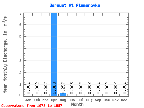
| Statistic | Jan | Feb | Mar | Apr | May | Jun | Jul | Aug | Sep | Oct | Nov | Dec | Annual |
|---|---|---|---|---|---|---|---|---|---|---|---|---|---|
| Mean | 0.00 | 0.00 | 0.01 | 6.98 | 0.26 | 0.00 | 0.00 | 0.00 | 0.00 | 0.00 | 0.00 | 0.00 | |
| Standard Deviation | 0.00 | 0.00 | 0.01 | 5.92 | 0.46 | 0.00 | 0.00 | 0.00 | 0.00 | 0.00 | 0.00 | 0.00 | |
| Min | 0.00 | 0.00 | 0.00 | 0.18 | 0.00 | 0.00 | 0.00 | 0.00 | 0.00 | 0.00 | 0.00 | 0.00 | |
| Max | 0.00 | 0.01 | 0.02 | 11.00 | 0.94 | 0.01 | 0.01 | 0.00 | 0.00 | 0.00 | 0.01 | 0.00 | |
| Coefficient of Variation | 1.05 | 1.68 | 1.73 | 0.85 | 1.78 | 0.67 | 0.87 | 0.70 | 0.78 | 0.65 | 1.06 | 0.96 |
 Return to R-Arctic Net Home Page