|
|
|||||||||||||||||
| Point ID: 7250 | Downloads | Plots | Site Data | Code: 12528 |
|
|
|||||||||||||||||
| Download | |
|---|---|
| Site Descriptor Information | Site Time Series Data |
| Link to all available data | |
| View: | Time Series | All |
| Units: | mm |
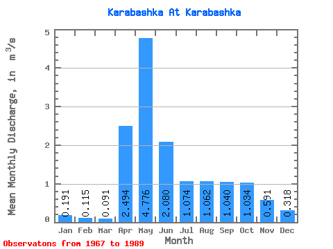
| Statistic | Jan | Feb | Mar | Apr | May | Jun | Jul | Aug | Sep | Oct | Nov | Dec | Annual |
|---|---|---|---|---|---|---|---|---|---|---|---|---|---|
| Mean | 0.19 | 0.12 | 0.09 | 2.49 | 4.78 | 2.08 | 1.07 | 1.06 | 1.04 | 1.03 | 0.59 | 0.32 | 1.30 |
| Standard Deviation | 0.16 | 0.11 | 0.08 | 1.43 | 2.86 | 1.30 | 0.90 | 1.22 | 1.11 | 1.02 | 0.55 | 0.26 | 0.63 |
| Min | 0.01 | 0.00 | 0.00 | 0.12 | 0.60 | 0.42 | 0.13 | 0.15 | 0.16 | 0.17 | 0.09 | 0.02 | 0.28 |
| Max | 0.56 | 0.38 | 0.27 | 4.82 | 10.90 | 4.49 | 2.85 | 3.98 | 3.85 | 3.73 | 2.11 | 0.83 | 2.65 |
| Coefficient of Variation | 0.84 | 0.96 | 0.85 | 0.57 | 0.60 | 0.62 | 0.84 | 1.15 | 1.07 | 0.99 | 0.92 | 0.82 | 0.49 |
 Return to R-Arctic Net Home Page