|
|
|||||||||||||||||
| Point ID: 7247 | Downloads | Plots | Site Data | Code: 12519 |
|
|
|||||||||||||||||
| Download | |
|---|---|
| Site Descriptor Information | Site Time Series Data |
| Link to all available data | |
| View: | Time Series | All |
| Units: | mm |
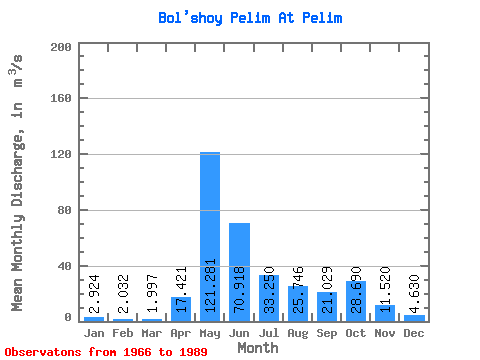
| Statistic | Jan | Feb | Mar | Apr | May | Jun | Jul | Aug | Sep | Oct | Nov | Dec | Annual |
|---|---|---|---|---|---|---|---|---|---|---|---|---|---|
| Mean | 2.92 | 2.03 | 2.00 | 17.42 | 121.28 | 70.92 | 33.25 | 25.75 | 21.03 | 28.69 | 11.52 | 4.63 | 26.86 |
| Standard Deviation | 1.14 | 0.75 | 0.64 | 22.29 | 55.32 | 48.91 | 35.72 | 24.76 | 14.58 | 20.72 | 8.20 | 2.73 | 8.66 |
| Min | 0.65 | 0.46 | 0.66 | 2.50 | 27.00 | 8.38 | 7.24 | 4.74 | 4.57 | 4.65 | 3.27 | 1.20 | 12.97 |
| Max | 4.65 | 3.29 | 2.90 | 97.20 | 250.00 | 184.00 | 118.00 | 98.70 | 61.90 | 74.40 | 30.40 | 10.20 | 41.49 |
| Coefficient of Variation | 0.39 | 0.37 | 0.32 | 1.28 | 0.46 | 0.69 | 1.07 | 0.96 | 0.69 | 0.72 | 0.71 | 0.59 | 0.32 |
 Return to R-Arctic Net Home Page