|
|
|||||||||||||||||
| Point ID: 723 | Downloads | Plots | Site Data | Code: 07DB005 |
|
|
|||||||||||||||||
| Download | |
|---|---|
| Site Descriptor Information | Site Time Series Data |
| Link to all available data | |
| View: | Time Series | All |
| Units: | mm |
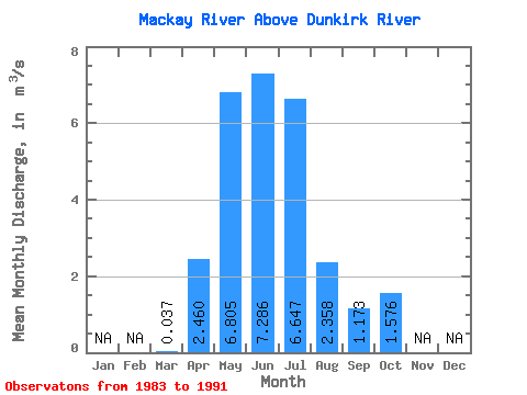
| Statistic | Jan | Feb | Mar | Apr | May | Jun | Jul | Aug | Sep | Oct | Nov | Dec | Annual |
|---|---|---|---|---|---|---|---|---|---|---|---|---|---|
| Mean | 0.04 | 2.46 | 6.80 | 7.29 | 6.65 | 2.36 | 1.17 | 1.58 | |||||
| Standard Deviation | 0.03 | 1.57 | 7.60 | 6.91 | 9.75 | 3.07 | 1.31 | 2.33 | |||||
| Min | 0.00 | 0.76 | 0.28 | 0.90 | 0.10 | 0.01 | 0.14 | 0.10 | |||||
| Max | 0.10 | 4.76 | 22.30 | 20.40 | 24.30 | 9.32 | 3.91 | 7.09 | |||||
| Coefficient of Variation | 0.82 | 0.64 | 1.12 | 0.95 | 1.47 | 1.30 | 1.12 | 1.48 |
 Return to R-Arctic Net Home Page