|
|
|||||||||||||||||
| Point ID: 7226 | Downloads | Plots | Site Data | Code: 12375 |
|
|
|||||||||||||||||
| Download | |
|---|---|
| Site Descriptor Information | Site Time Series Data |
| Link to all available data | |
| View: | Time Series | All |
| Units: | mm |
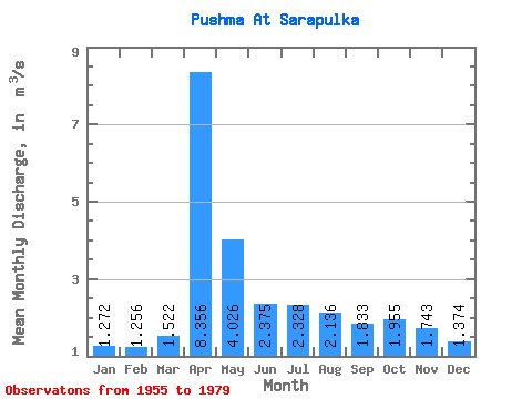
| Statistic | Jan | Feb | Mar | Apr | May | Jun | Jul | Aug | Sep | Oct | Nov | Dec | Annual |
|---|---|---|---|---|---|---|---|---|---|---|---|---|---|
| Mean | 1.27 | 1.26 | 1.52 | 8.36 | 4.03 | 2.38 | 2.33 | 2.14 | 1.83 | 1.96 | 1.74 | 1.37 | 2.47 |
| Standard Deviation | 0.37 | 0.32 | 0.55 | 3.43 | 2.40 | 0.87 | 1.54 | 1.58 | 0.54 | 0.59 | 0.59 | 0.39 | 0.58 |
| Min | 0.41 | 0.64 | 0.79 | 2.86 | 1.63 | 0.87 | 1.03 | 0.78 | 1.11 | 1.22 | 1.00 | 0.63 | 1.71 |
| Max | 2.06 | 2.07 | 3.22 | 15.20 | 13.90 | 4.35 | 7.32 | 6.87 | 3.19 | 3.41 | 3.08 | 2.16 | 3.73 |
| Coefficient of Variation | 0.29 | 0.26 | 0.36 | 0.41 | 0.60 | 0.37 | 0.66 | 0.74 | 0.29 | 0.30 | 0.34 | 0.28 | 0.23 |
 Return to R-Arctic Net Home Page