|
|
|||||||||||||||||
| Point ID: 7222 | Downloads | Plots | Site Data | Code: 12341 |
|
|
|||||||||||||||||
| Download | |
|---|---|
| Site Descriptor Information | Site Time Series Data |
| Link to all available data | |
| View: | Time Series | All |
| Units: | mm |
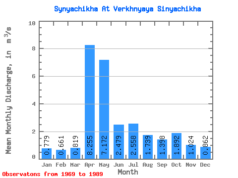
| Statistic | Jan | Feb | Mar | Apr | May | Jun | Jul | Aug | Sep | Oct | Nov | Dec | Annual |
|---|---|---|---|---|---|---|---|---|---|---|---|---|---|
| Mean | 0.78 | 0.66 | 0.82 | 8.26 | 7.17 | 2.48 | 2.56 | 1.74 | 1.40 | 1.89 | 1.02 | 0.86 | 2.47 |
| Standard Deviation | 0.26 | 0.18 | 0.35 | 6.17 | 6.77 | 2.59 | 3.57 | 2.68 | 1.33 | 2.31 | 0.52 | 0.36 | 1.08 |
| Min | 0.30 | 0.29 | 0.12 | 0.92 | 1.26 | 0.70 | 0.44 | 0.39 | 0.34 | 0.36 | 0.37 | 0.32 | 0.90 |
| Max | 1.29 | 0.96 | 1.47 | 20.40 | 26.80 | 12.40 | 13.20 | 12.60 | 4.96 | 10.40 | 2.42 | 1.72 | 4.20 |
| Coefficient of Variation | 0.33 | 0.27 | 0.43 | 0.75 | 0.94 | 1.05 | 1.40 | 1.54 | 0.95 | 1.22 | 0.51 | 0.42 | 0.44 |
 Return to R-Arctic Net Home Page