|
|
|||||||||||||||||
| Point ID: 721 | Downloads | Plots | Site Data | Code: 07DB003 |
|
|
|||||||||||||||||
| Download | |
|---|---|
| Site Descriptor Information | Site Time Series Data |
| Link to all available data | |
| View: | Time Series | All |
| Units: | mm |
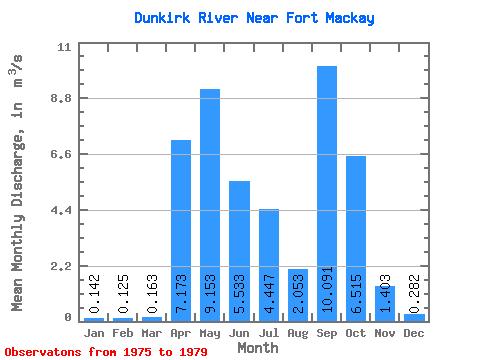
| Statistic | Jan | Feb | Mar | Apr | May | Jun | Jul | Aug | Sep | Oct | Nov | Dec | Annual |
|---|---|---|---|---|---|---|---|---|---|---|---|---|---|
| Mean | 0.14 | 0.12 | 0.16 | 7.17 | 9.15 | 5.53 | 4.45 | 2.05 | 10.09 | 6.51 | 1.40 | 0.28 | 3.76 |
| Standard Deviation | 0.10 | 0.06 | 0.08 | 7.74 | 5.64 | 1.51 | 2.99 | 0.52 | 10.50 | 6.09 | 0.99 | 0.23 | 1.81 |
| Min | 0.03 | 0.06 | 0.05 | 2.28 | 4.70 | 4.35 | 1.97 | 1.46 | 0.95 | 1.90 | 0.41 | 0.07 | 2.23 |
| Max | 0.27 | 0.20 | 0.23 | 16.10 | 15.50 | 7.23 | 7.77 | 2.45 | 23.10 | 14.80 | 2.50 | 0.62 | 5.76 |
| Coefficient of Variation | 0.73 | 0.44 | 0.52 | 1.08 | 0.62 | 0.27 | 0.67 | 0.26 | 1.04 | 0.94 | 0.70 | 0.83 | 0.48 |
 Return to R-Arctic Net Home Page