|
|
|||||||||||||||||
| Point ID: 7205 | Downloads | Plots | Site Data | Code: 12222 |
|
|
|||||||||||||||||
| Download | |
|---|---|
| Site Descriptor Information | Site Time Series Data |
| Link to all available data | |
| View: | Time Series | All |
| Units: | mm |
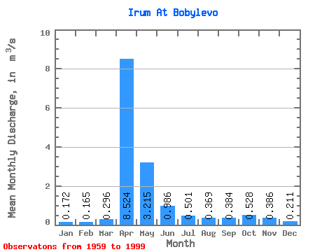
| Statistic | Jan | Feb | Mar | Apr | May | Jun | Jul | Aug | Sep | Oct | Nov | Dec | Annual |
|---|---|---|---|---|---|---|---|---|---|---|---|---|---|
| Mean | 0.17 | 0.17 | 0.30 | 8.52 | 3.21 | 0.99 | 0.50 | 0.37 | 0.38 | 0.53 | 0.39 | 0.21 | 1.33 |
| Standard Deviation | 0.08 | 0.08 | 0.47 | 5.94 | 2.84 | 0.81 | 0.45 | 0.45 | 0.43 | 0.55 | 0.32 | 0.10 | 0.76 |
| Min | 0.07 | 0.04 | 0.05 | 1.71 | 0.58 | 0.08 | 0.04 | 0.05 | 0.08 | 0.03 | 0.07 | 0.07 | 0.36 |
| Max | 0.40 | 0.40 | 2.99 | 23.10 | 14.60 | 3.77 | 1.72 | 2.16 | 2.32 | 2.50 | 1.26 | 0.50 | 3.12 |
| Coefficient of Variation | 0.46 | 0.48 | 1.57 | 0.70 | 0.89 | 0.82 | 0.90 | 1.21 | 1.13 | 1.03 | 0.82 | 0.48 | 0.57 |
 Return to R-Arctic Net Home Page