|
|
|||||||||||||||||
| Point ID: 7191 | Downloads | Plots | Site Data | Code: 12155 |
|
|
|||||||||||||||||
| Download | |
|---|---|
| Site Descriptor Information | Site Time Series Data |
| Link to all available data | |
| View: | Time Series | All |
| Units: | mm |
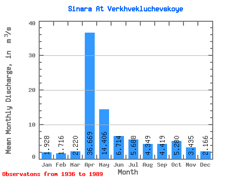
| Statistic | Jan | Feb | Mar | Apr | May | Jun | Jul | Aug | Sep | Oct | Nov | Dec | Annual |
|---|---|---|---|---|---|---|---|---|---|---|---|---|---|
| Mean | 1.93 | 1.72 | 2.22 | 36.67 | 14.41 | 6.71 | 5.69 | 4.35 | 4.42 | 5.28 | 3.44 | 2.17 | 7.53 |
| Standard Deviation | 1.08 | 0.86 | 1.83 | 24.28 | 14.22 | 5.21 | 5.17 | 3.68 | 3.66 | 5.42 | 2.10 | 1.14 | 4.49 |
| Min | 0.38 | 0.34 | 0.39 | 3.78 | 2.30 | 1.34 | 0.86 | 0.99 | 0.93 | 0.89 | 0.82 | 0.16 | 1.92 |
| Max | 5.50 | 4.50 | 12.60 | 120.00 | 78.60 | 30.20 | 30.80 | 19.10 | 15.90 | 34.50 | 9.62 | 5.44 | 24.04 |
| Coefficient of Variation | 0.56 | 0.50 | 0.82 | 0.66 | 0.99 | 0.78 | 0.91 | 0.85 | 0.83 | 1.03 | 0.61 | 0.53 | 0.60 |
 Return to R-Arctic Net Home Page