|
|
|||||||||||||||||
| Point ID: 7186 | Downloads | Plots | Site Data | Code: 12133 |
|
|
|||||||||||||||||
| Download | |
|---|---|
| Site Descriptor Information | Site Time Series Data |
| Link to all available data | |
| View: | Time Series | All |
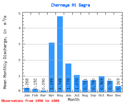
| Units: | mm |
| Statistic | Jan | Feb | Mar | Apr | May | Jun | Jul | Aug | Sep | Oct | Nov | Dec | Annual |
|---|---|---|---|---|---|---|---|---|---|---|---|---|---|
| Mean | 0.27 | 0.19 | 0.09 | 3.10 | 4.75 | 1.78 | 1.07 | 0.73 | 0.74 | 0.97 | 0.71 | 0.37 | 1.28 |
| Standard Deviation | 0.55 | 0.48 | 0.07 | 1.82 | 3.08 | 1.19 | 1.10 | 1.05 | 0.91 | 1.01 | 0.81 | 0.53 | 0.39 |
| Min | 0.00 | 0.00 | 0.00 | 0.68 | 0.43 | 0.17 | 0.03 | 0.01 | 0.04 | 0.07 | 0.06 | 0.02 | 0.65 |
| Max | 3.16 | 2.60 | 0.28 | 7.71 | 15.40 | 5.60 | 5.16 | 6.00 | 4.27 | 3.90 | 3.81 | 3.05 | 2.08 |
| Coefficient of Variation | 2.07 | 2.49 | 0.77 | 0.59 | 0.65 | 0.67 | 1.03 | 1.43 | 1.22 | 1.04 | 1.15 | 1.44 | 0.30 |
 Return to R-Arctic Net Home Page