|
|
|||||||||||||||||
| Point ID: 7172 | Downloads | Plots | Site Data | Code: 12089 |
|
|
|||||||||||||||||
| Download | |
|---|---|
| Site Descriptor Information | Site Time Series Data |
| Link to all available data | |
| View: | Time Series | All |
| Units: | mm |
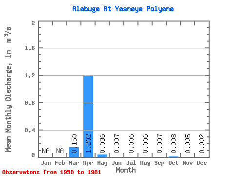
| Statistic | Jan | Feb | Mar | Apr | May | Jun | Jul | Aug | Sep | Oct | Nov | Dec | Annual |
|---|---|---|---|---|---|---|---|---|---|---|---|---|---|
| Mean | 0.15 | 1.20 | 0.04 | 0.01 | 0.01 | 0.01 | 0.01 | 0.01 | 0.01 | 0.00 | |||
| Standard Deviation | 0.16 | 1.10 | 0.03 | 0.01 | 0.01 | 0.01 | 0.01 | 0.01 | 0.00 | 0.00 | |||
| Min | 0.01 | 0.01 | 0.01 | 0.00 | 0.00 | 0.00 | 0.00 | 0.00 | 0.00 | 0.00 | |||
| Max | 0.37 | 3.53 | 0.11 | 0.03 | 0.03 | 0.04 | 0.04 | 0.02 | 0.01 | 0.00 | |||
| Coefficient of Variation | 1.06 | 0.92 | 0.81 | 0.87 | 1.16 | 1.65 | 1.20 | 0.59 | 0.71 | 0.45 |
 Return to R-Arctic Net Home Page