|
|
|||||||||||||||||
| Point ID: 7166 | Downloads | Plots | Site Data | Code: 12054 |
|
|
|||||||||||||||||
| Download | |
|---|---|
| Site Descriptor Information | Site Time Series Data |
| Link to all available data | |
| View: | Time Series | All |
| Units: | mm |
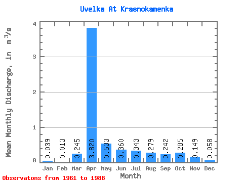
| Statistic | Jan | Feb | Mar | Apr | May | Jun | Jul | Aug | Sep | Oct | Nov | Dec | Annual |
|---|---|---|---|---|---|---|---|---|---|---|---|---|---|
| Mean | 0.04 | 0.01 | 0.24 | 3.82 | 0.53 | 0.36 | 0.34 | 0.28 | 0.24 | 0.28 | 0.15 | 0.06 | 0.61 |
| Standard Deviation | 0.04 | 0.02 | 0.44 | 2.19 | 0.35 | 0.18 | 0.24 | 0.21 | 0.20 | 0.22 | 0.12 | 0.05 | 0.21 |
| Min | 0.00 | 0.00 | 0.00 | 0.52 | 0.06 | 0.03 | 0.04 | 0.05 | 0.03 | 0.02 | 0.01 | 0.00 | 0.33 |
| Max | 0.10 | 0.06 | 1.58 | 9.21 | 1.44 | 0.70 | 0.86 | 0.83 | 0.89 | 0.82 | 0.49 | 0.22 | 0.88 |
| Coefficient of Variation | 0.91 | 1.54 | 1.79 | 0.57 | 0.67 | 0.50 | 0.70 | 0.75 | 0.84 | 0.76 | 0.81 | 0.92 | 0.35 |
 Return to R-Arctic Net Home Page