|
|
|||||||||||||||||
| Point ID: 7165 | Downloads | Plots | Site Data | Code: 12053 |
|
|
|||||||||||||||||
| Download | |
|---|---|
| Site Descriptor Information | Site Time Series Data |
| Link to all available data | |
| View: | Time Series | All |
| Units: | mm |
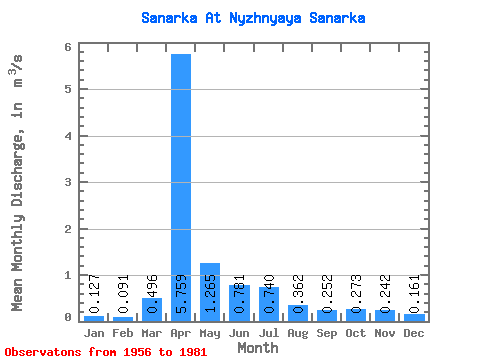
| Statistic | Jan | Feb | Mar | Apr | May | Jun | Jul | Aug | Sep | Oct | Nov | Dec | Annual |
|---|---|---|---|---|---|---|---|---|---|---|---|---|---|
| Mean | 0.13 | 0.09 | 0.50 | 5.76 | 1.27 | 0.78 | 0.74 | 0.36 | 0.25 | 0.27 | 0.24 | 0.16 | 1.11 |
| Standard Deviation | 0.11 | 0.09 | 0.71 | 4.50 | 1.04 | 1.14 | 1.32 | 0.67 | 0.26 | 0.22 | 0.15 | 0.17 | 0.62 |
| Min | 0.00 | 0.00 | 0.02 | 0.46 | 0.10 | 0.00 | 0.02 | 0.01 | 0.00 | 0.00 | 0.07 | 0.00 | 0.30 |
| Max | 0.38 | 0.23 | 2.51 | 21.40 | 4.35 | 5.53 | 4.64 | 3.28 | 1.09 | 0.89 | 0.66 | 0.76 | 2.45 |
| Coefficient of Variation | 0.86 | 0.93 | 1.43 | 0.78 | 0.82 | 1.46 | 1.79 | 1.84 | 1.02 | 0.80 | 0.62 | 1.09 | 0.56 |
 Return to R-Arctic Net Home Page