|
|
|||||||||||||||||
| Point ID: 7164 | Downloads | Plots | Site Data | Code: 12051 |
|
|
|||||||||||||||||
| Download | |
|---|---|
| Site Descriptor Information | Site Time Series Data |
| Link to all available data | |
| View: | Time Series | All |
| Units: | mm |
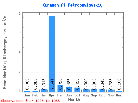
| Statistic | Jan | Feb | Mar | Apr | May | Jun | Jul | Aug | Sep | Oct | Nov | Dec | Annual |
|---|---|---|---|---|---|---|---|---|---|---|---|---|---|
| Mean | 0.07 | 0.09 | 0.31 | 7.64 | 0.74 | 0.48 | 0.45 | 0.30 | 0.30 | 0.34 | 0.24 | 0.11 | 1.22 |
| Standard Deviation | 0.14 | 0.18 | 0.47 | 6.36 | 0.63 | 0.77 | 0.70 | 0.38 | 0.59 | 0.60 | 0.34 | 0.17 | 0.88 |
| Min | 0.00 | 0.00 | 0.00 | 1.03 | 0.09 | 0.04 | 0.02 | 0.01 | 0.01 | 0.00 | 0.03 | 0.01 | 0.40 |
| Max | 0.49 | 0.46 | 2.07 | 24.40 | 2.81 | 4.34 | 2.43 | 1.70 | 3.12 | 3.11 | 1.67 | 0.60 | 2.44 |
| Coefficient of Variation | 2.01 | 2.17 | 1.52 | 0.83 | 0.85 | 1.58 | 1.54 | 1.26 | 1.94 | 1.77 | 1.45 | 1.56 | 0.72 |
 Return to R-Arctic Net Home Page