|
|
|||||||||||||||||
| Point ID: 7153 | Downloads | Plots | Site Data | Code: 12015 |
|
|
|||||||||||||||||
| Download | |
|---|---|
| Site Descriptor Information | Site Time Series Data |
| Link to all available data | |
| View: | Time Series | All |
| Units: | mm |
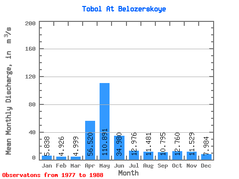
| Statistic | Jan | Feb | Mar | Apr | May | Jun | Jul | Aug | Sep | Oct | Nov | Dec | Annual |
|---|---|---|---|---|---|---|---|---|---|---|---|---|---|
| Mean | 5.84 | 4.93 | 5.00 | 56.52 | 110.89 | 34.98 | 12.98 | 11.48 | 10.79 | 12.76 | 11.53 | 7.98 | 25.53 |
| Standard Deviation | 3.65 | 2.72 | 2.47 | 25.19 | 71.35 | 33.27 | 7.38 | 8.37 | 8.56 | 6.72 | 5.11 | 4.58 | 14.47 |
| Min | 0.50 | 0.26 | 0.58 | 21.60 | 26.20 | 4.61 | 3.68 | 3.27 | 2.38 | 5.65 | 5.61 | 3.58 | 10.77 |
| Max | 13.90 | 10.20 | 8.81 | 90.40 | 286.00 | 125.00 | 25.20 | 25.10 | 25.80 | 26.80 | 23.10 | 18.90 | 54.73 |
| Coefficient of Variation | 0.62 | 0.55 | 0.49 | 0.45 | 0.64 | 0.95 | 0.57 | 0.73 | 0.79 | 0.53 | 0.44 | 0.57 | 0.57 |
 Return to R-Arctic Net Home Page