|
|
|||||||||||||||||
| Point ID: 7129 | Downloads | Plots | Site Data | Code: 11612 |
|
|
|||||||||||||||||
| Download | |
|---|---|
| Site Descriptor Information | Site Time Series Data |
| Link to all available data | |
| View: | Time Series | All |
| Units: | mm |
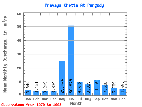
| Statistic | Jan | Feb | Mar | Apr | May | Jun | Jul | Aug | Sep | Oct | Nov | Dec | Annual |
|---|---|---|---|---|---|---|---|---|---|---|---|---|---|
| Mean | 3.84 | 3.45 | 3.21 | 3.33 | 25.04 | 50.68 | 9.62 | 8.04 | 11.16 | 7.70 | 5.79 | 4.67 | 11.66 |
| Standard Deviation | 0.68 | 0.77 | 0.67 | 0.54 | 21.72 | 30.72 | 2.53 | 1.49 | 5.05 | 1.84 | 0.96 | 0.71 | 1.32 |
| Min | 2.69 | 2.04 | 2.30 | 2.47 | 2.81 | 12.70 | 6.43 | 5.81 | 6.11 | 5.55 | 4.31 | 3.67 | 9.88 |
| Max | 5.25 | 4.86 | 4.52 | 4.51 | 62.30 | 107.00 | 15.00 | 10.30 | 24.50 | 12.90 | 7.56 | 5.67 | 14.33 |
| Coefficient of Variation | 0.18 | 0.22 | 0.21 | 0.16 | 0.87 | 0.61 | 0.26 | 0.18 | 0.45 | 0.24 | 0.17 | 0.15 | 0.11 |
 Return to R-Arctic Net Home Page