|
|
|||||||||||||||||
| Point ID: 710 | Downloads | Plots | Site Data | Code: 07DA011 |
|
|
|||||||||||||||||
| Download | |
|---|---|
| Site Descriptor Information | Site Time Series Data |
| Link to all available data | |
| View: | Time Series | All |
| Units: | mm |
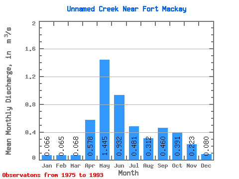
| Statistic | Jan | Feb | Mar | Apr | May | Jun | Jul | Aug | Sep | Oct | Nov | Dec | Annual |
|---|---|---|---|---|---|---|---|---|---|---|---|---|---|
| Mean | 0.07 | 0.07 | 0.07 | 0.58 | 1.45 | 0.93 | 0.48 | 0.31 | 0.46 | 0.39 | 0.22 | 0.08 | 0.46 |
| Standard Deviation | 0.02 | 0.02 | 0.03 | 0.30 | 1.28 | 0.77 | 0.51 | 0.23 | 0.60 | 0.29 | 0.11 | 0.06 | 0.26 |
| Min | 0.04 | 0.04 | 0.01 | 0.11 | 0.18 | 0.07 | 0.06 | 0.07 | 0.07 | 0.07 | 0.11 | 0.03 | 0.20 |
| Max | 0.11 | 0.09 | 0.14 | 1.21 | 4.90 | 2.34 | 2.25 | 1.04 | 2.65 | 1.30 | 0.35 | 0.18 | 0.77 |
| Coefficient of Variation | 0.36 | 0.38 | 0.42 | 0.52 | 0.89 | 0.82 | 1.06 | 0.73 | 1.30 | 0.75 | 0.49 | 0.69 | 0.57 |
 Return to R-Arctic Net Home Page