|
|
|||||||||||||||||
| Point ID: 7075 | Downloads | Plots | Site Data | Code: 11482 |
|
|
|||||||||||||||||
| Download | |
|---|---|
| Site Descriptor Information | Site Time Series Data |
| Link to all available data | |
| View: | Time Series | All |
| Units: | mm |
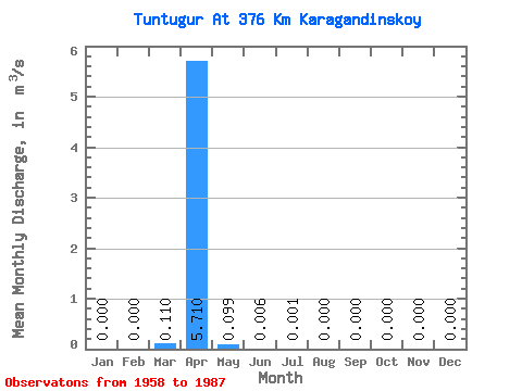
| Statistic | Jan | Feb | Mar | Apr | May | Jun | Jul | Aug | Sep | Oct | Nov | Dec | Annual |
|---|---|---|---|---|---|---|---|---|---|---|---|---|---|
| Mean | 0.00 | 0.00 | 0.11 | 5.71 | 0.10 | 0.01 | 0.00 | 0.00 | 0.00 | 0.00 | 0.00 | 0.00 | 1.12 |
| Standard Deviation | 0.00 | 0.00 | 0.19 | 4.59 | 0.32 | 0.01 | 0.00 | 0.00 | 0.00 | 0.00 | 0.00 | 0.00 | 0.41 |
| Min | 0.00 | 0.00 | 0.00 | 0.13 | 0.00 | 0.00 | 0.00 | 0.00 | 0.00 | 0.00 | 0.00 | 0.00 | 0.83 |
| Max | 0.00 | 0.00 | 0.49 | 15.50 | 1.46 | 0.01 | 0.00 | 0.00 | 0.00 | 0.00 | 0.00 | 0.00 | 1.41 |
| Coefficient of Variation | 1.73 | 0.80 | 3.20 | 1.06 | 1.73 | 0.36 |
 Return to R-Arctic Net Home Page