|
|
|||||||||||||||||
| Point ID: 7071 | Downloads | Plots | Site Data | Code: 11468 |
|
|
|||||||||||||||||
| Download | |
|---|---|
| Site Descriptor Information | Site Time Series Data |
| Link to all available data | |
| View: | Time Series | All |
| Units: | mm |
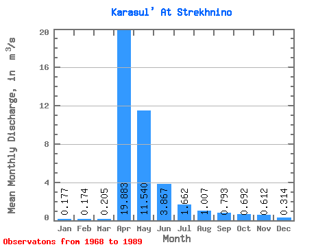
| Statistic | Jan | Feb | Mar | Apr | May | Jun | Jul | Aug | Sep | Oct | Nov | Dec | Annual |
|---|---|---|---|---|---|---|---|---|---|---|---|---|---|
| Mean | 0.18 | 0.17 | 0.20 | 19.88 | 11.54 | 3.87 | 1.66 | 1.01 | 0.79 | 0.69 | 0.61 | 0.31 | 3.32 |
| Standard Deviation | 0.10 | 0.08 | 0.11 | 16.50 | 12.76 | 4.19 | 2.21 | 1.11 | 0.92 | 0.74 | 0.66 | 0.27 | 2.77 |
| Min | 0.02 | 0.07 | 0.08 | 3.44 | 0.26 | 0.01 | 0.01 | 0.00 | 0.03 | 0.04 | 0.04 | 0.04 | 0.75 |
| Max | 0.34 | 0.35 | 0.46 | 61.00 | 51.10 | 15.00 | 7.17 | 3.61 | 3.75 | 3.10 | 2.26 | 0.97 | 9.31 |
| Coefficient of Variation | 0.54 | 0.47 | 0.52 | 0.83 | 1.10 | 1.08 | 1.33 | 1.10 | 1.16 | 1.07 | 1.08 | 0.85 | 0.84 |
 Return to R-Arctic Net Home Page