|
|
|||||||||||||||||
| Point ID: 7065 | Downloads | Plots | Site Data | Code: 11434 |
|
|
|||||||||||||||||
| Download | |
|---|---|
| Site Descriptor Information | Site Time Series Data |
| Link to all available data | |
| View: | Time Series | All |
| Units: | mm |
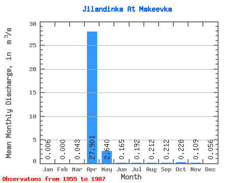
| Statistic | Jan | Feb | Mar | Apr | May | Jun | Jul | Aug | Sep | Oct | Nov | Dec | Annual |
|---|---|---|---|---|---|---|---|---|---|---|---|---|---|
| Mean | 0.01 | 0.00 | 0.04 | 27.90 | 2.64 | 0.17 | 0.19 | 0.21 | 0.21 | 0.23 | 0.11 | 0.06 | |
| Standard Deviation | 0.01 | 0.00 | 0.05 | 20.53 | 3.25 | 0.11 | 0.18 | 0.18 | 0.25 | 0.14 | 0.08 | 0.06 | |
| Min | 0.00 | 0.00 | 0.00 | 2.98 | 0.57 | 0.00 | 0.00 | 0.00 | 0.00 | 0.00 | 0.00 | 0.00 | |
| Max | 0.02 | 0.00 | 0.15 | 76.20 | 13.60 | 0.32 | 0.62 | 0.58 | 0.94 | 0.44 | 0.24 | 0.20 | |
| Coefficient of Variation | 1.16 | 1.10 | 0.74 | 1.23 | 0.67 | 0.94 | 0.84 | 1.19 | 0.62 | 0.75 | 1.10 |
 Return to R-Arctic Net Home Page