|
|
|||||||||||||||||
| Point ID: 7064 | Downloads | Plots | Site Data | Code: 11433 |
|
|
|||||||||||||||||
| Download | |
|---|---|
| Site Descriptor Information | Site Time Series Data |
| Link to all available data | |
| View: | Time Series | All |
| Units: | mm |
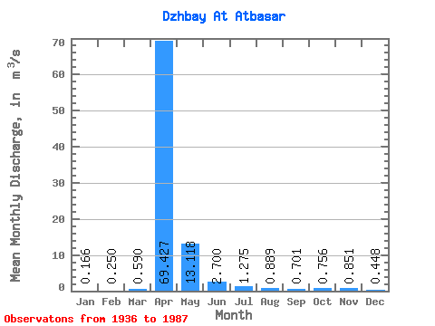
| Statistic | Jan | Feb | Mar | Apr | May | Jun | Jul | Aug | Sep | Oct | Nov | Dec | Annual |
|---|---|---|---|---|---|---|---|---|---|---|---|---|---|
| Mean | 0.17 | 0.25 | 0.59 | 69.43 | 13.12 | 2.70 | 1.27 | 0.89 | 0.70 | 0.76 | 0.85 | 0.45 | 12.28 |
| Standard Deviation | 0.23 | 0.30 | 1.53 | 55.98 | 13.52 | 2.92 | 1.25 | 1.13 | 0.64 | 0.56 | 0.76 | 0.53 | 6.36 |
| Min | 0.00 | 0.00 | 0.01 | 3.14 | 2.07 | 0.29 | 0.09 | 0.04 | 0.04 | 0.05 | 0.01 | 0.00 | 5.70 |
| Max | 0.79 | 0.82 | 7.64 | 285.00 | 68.30 | 13.90 | 5.64 | 7.26 | 2.55 | 2.07 | 3.27 | 2.28 | 27.45 |
| Coefficient of Variation | 1.40 | 1.20 | 2.59 | 0.81 | 1.03 | 1.08 | 0.98 | 1.27 | 0.91 | 0.74 | 0.89 | 1.17 | 0.52 |
 Return to R-Arctic Net Home Page