|
|
|||||||||||||||||
| Point ID: 7043 | Downloads | Plots | Site Data | Code: 11384 |
|
|
|||||||||||||||||
| Download | |
|---|---|
| Site Descriptor Information | Site Time Series Data |
| Link to all available data | |
| View: | Time Series | All |
| Units: | mm |
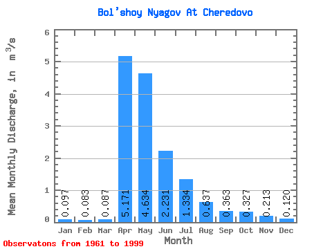
| Statistic | Jan | Feb | Mar | Apr | May | Jun | Jul | Aug | Sep | Oct | Nov | Dec | Annual |
|---|---|---|---|---|---|---|---|---|---|---|---|---|---|
| Mean | 0.10 | 0.08 | 0.09 | 5.17 | 4.63 | 2.23 | 1.33 | 0.64 | 0.36 | 0.33 | 0.21 | 0.12 | 1.24 |
| Standard Deviation | 0.07 | 0.07 | 0.06 | 4.93 | 4.64 | 3.22 | 2.87 | 1.24 | 0.56 | 0.42 | 0.23 | 0.09 | 1.09 |
| Min | 0.02 | 0.00 | 0.00 | 0.15 | 0.06 | 0.05 | 0.00 | 0.03 | 0.03 | 0.04 | 0.03 | 0.01 | 0.04 |
| Max | 0.26 | 0.26 | 0.26 | 18.30 | 19.30 | 15.40 | 15.20 | 5.09 | 2.89 | 2.00 | 0.92 | 0.36 | 4.05 |
| Coefficient of Variation | 0.69 | 0.79 | 0.64 | 0.95 | 1.00 | 1.44 | 2.15 | 1.95 | 1.55 | 1.27 | 1.07 | 0.76 | 0.87 |
 Return to R-Arctic Net Home Page