|
|
|||||||||||||||||
| Point ID: 7041 | Downloads | Plots | Site Data | Code: 11381 |
|
|
|||||||||||||||||
| Download | |
|---|---|
| Site Descriptor Information | Site Time Series Data |
| Link to all available data | |
| View: | Time Series | All |
| Units: | mm |
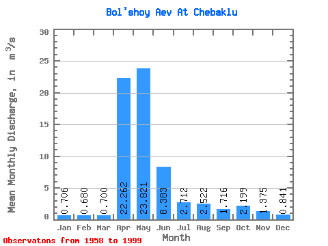
| Statistic | Jan | Feb | Mar | Apr | May | Jun | Jul | Aug | Sep | Oct | Nov | Dec | Annual |
|---|---|---|---|---|---|---|---|---|---|---|---|---|---|
| Mean | 0.71 | 0.68 | 0.70 | 22.26 | 23.82 | 8.38 | 2.71 | 2.52 | 1.72 | 2.20 | 1.38 | 0.84 | 5.67 |
| Standard Deviation | 0.28 | 0.25 | 0.24 | 17.80 | 20.75 | 9.44 | 2.68 | 4.14 | 1.73 | 2.64 | 1.00 | 0.40 | 3.67 |
| Min | 0.27 | 0.25 | 0.26 | 2.03 | 0.81 | 0.42 | 0.30 | 0.23 | 0.28 | 0.41 | 0.27 | 0.27 | 0.53 |
| Max | 1.29 | 1.25 | 1.23 | 72.20 | 70.20 | 39.50 | 13.30 | 19.90 | 7.96 | 12.10 | 4.47 | 1.82 | 12.92 |
| Coefficient of Variation | 0.39 | 0.37 | 0.34 | 0.80 | 0.87 | 1.13 | 0.99 | 1.64 | 1.01 | 1.20 | 0.73 | 0.48 | 0.65 |
 Return to R-Arctic Net Home Page