|
|
|||||||||||||||||
| Point ID: 7015 | Downloads | Plots | Site Data | Code: 11322 |
|
|
|||||||||||||||||
| Download | |
|---|---|
| Site Descriptor Information | Site Time Series Data |
| Link to all available data | |
| View: | Time Series | All |
| Units: | mm |
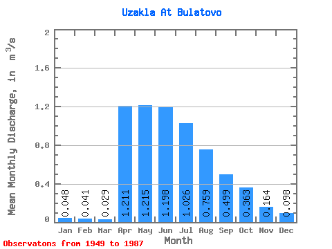
| Statistic | Jan | Feb | Mar | Apr | May | Jun | Jul | Aug | Sep | Oct | Nov | Dec | Annual |
|---|---|---|---|---|---|---|---|---|---|---|---|---|---|
| Mean | 0.05 | 0.04 | 0.03 | 1.21 | 1.22 | 1.20 | 1.03 | 0.76 | 0.50 | 0.36 | 0.16 | 0.10 | 1.68 |
| Standard Deviation | 0.05 | 0.04 | 0.03 | 0.90 | 1.48 | 1.67 | 1.48 | 1.09 | 0.75 | 0.63 | 0.25 | 0.13 | 0.53 |
| Min | 0.00 | 0.00 | 0.00 | 0.07 | 0.01 | 0.00 | 0.00 | 0.00 | 0.00 | 0.00 | 0.00 | 0.00 | 1.35 |
| Max | 0.13 | 0.09 | 0.06 | 3.94 | 5.47 | 5.77 | 5.16 | 3.98 | 2.60 | 2.77 | 0.79 | 0.38 | 2.29 |
| Coefficient of Variation | 1.02 | 0.93 | 1.02 | 0.75 | 1.22 | 1.40 | 1.44 | 1.44 | 1.49 | 1.74 | 1.51 | 1.33 | 0.31 |
 Return to R-Arctic Net Home Page