|
|
|||||||||||||||||
| Point ID: 7014 | Downloads | Plots | Site Data | Code: 11319 |
|
|
|||||||||||||||||
| Download | |
|---|---|
| Site Descriptor Information | Site Time Series Data |
| Link to all available data | |
| View: | Time Series | All |
| Units: | mm |
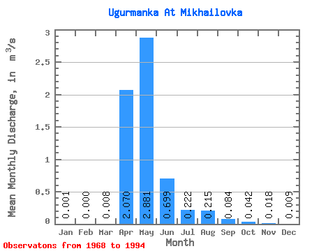
| Statistic | Jan | Feb | Mar | Apr | May | Jun | Jul | Aug | Sep | Oct | Nov | Dec | Annual |
|---|---|---|---|---|---|---|---|---|---|---|---|---|---|
| Mean | 0.00 | 0.00 | 0.01 | 2.07 | 2.88 | 0.70 | 0.22 | 0.21 | 0.08 | 0.04 | 0.02 | 0.01 | 0.57 |
| Standard Deviation | 0.00 | 0.00 | 0.02 | 1.88 | 2.94 | 1.20 | 0.44 | 0.53 | 0.22 | 0.06 | 0.02 | 0.02 | 0.68 |
| Min | 0.00 | 0.00 | 0.00 | 0.05 | 0.01 | 0.00 | 0.00 | 0.00 | 0.00 | 0.00 | 0.00 | 0.00 | 0.08 |
| Max | 0.01 | 0.00 | 0.07 | 7.81 | 11.20 | 5.22 | 1.71 | 2.12 | 0.91 | 0.18 | 0.08 | 0.05 | 2.14 |
| Coefficient of Variation | 3.16 | 2.88 | 0.91 | 1.02 | 1.71 | 1.97 | 2.47 | 2.63 | 1.47 | 1.35 | 1.99 | 1.19 |
 Return to R-Arctic Net Home Page