|
|
|||||||||||||||||
| Point ID: 7009 | Downloads | Plots | Site Data | Code: 11309 |
|
|
|||||||||||||||||
| Download | |
|---|---|
| Site Descriptor Information | Site Time Series Data |
| Link to all available data | |
| View: | Time Series | All |
| Units: | mm |
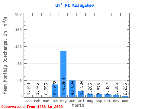
| Statistic | Jan | Feb | Mar | Apr | May | Jun | Jul | Aug | Sep | Oct | Nov | Dec | Annual |
|---|---|---|---|---|---|---|---|---|---|---|---|---|---|
| Mean | 1.35 | 1.04 | 0.95 | 30.68 | 109.06 | 40.60 | 15.38 | 9.21 | 7.98 | 8.44 | 5.87 | 2.23 | 18.38 |
| Standard Deviation | 1.08 | 0.77 | 0.63 | 29.21 | 83.70 | 49.75 | 22.84 | 14.20 | 12.54 | 12.62 | 7.47 | 2.38 | 14.21 |
| Min | 0.24 | 0.17 | 0.20 | 2.66 | 3.44 | 0.75 | 0.26 | 0.17 | 0.04 | 0.08 | 0.23 | 0.33 | 1.42 |
| Max | 5.12 | 4.53 | 4.18 | 169.00 | 344.00 | 304.00 | 137.00 | 69.20 | 59.30 | 64.80 | 27.10 | 12.80 | 56.51 |
| Coefficient of Variation | 0.80 | 0.74 | 0.66 | 0.95 | 0.77 | 1.23 | 1.48 | 1.54 | 1.57 | 1.50 | 1.27 | 1.07 | 0.77 |
 Return to R-Arctic Net Home Page