|
|
|||||||||||||||||
| Point ID: 7007 | Downloads | Plots | Site Data | Code: 11306 |
|
|
|||||||||||||||||
| Download | |
|---|---|
| Site Descriptor Information | Site Time Series Data |
| Link to all available data | |
| View: | Time Series | All |
| Units: | mm |
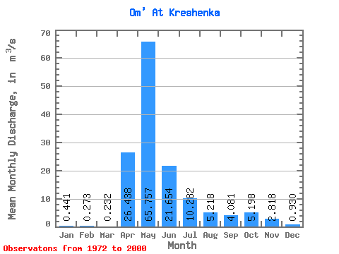
| Statistic | Jan | Feb | Mar | Apr | May | Jun | Jul | Aug | Sep | Oct | Nov | Dec | Annual |
|---|---|---|---|---|---|---|---|---|---|---|---|---|---|
| Mean | 0.44 | 0.27 | 0.23 | 26.44 | 65.76 | 21.65 | 10.28 | 5.22 | 4.08 | 5.20 | 2.82 | 0.93 | 11.40 |
| Standard Deviation | 0.59 | 0.32 | 0.23 | 27.05 | 53.79 | 21.30 | 24.44 | 11.52 | 8.05 | 8.70 | 4.23 | 1.44 | 9.37 |
| Min | 0.05 | 0.04 | 0.06 | 1.44 | 3.74 | 0.53 | 0.13 | 0.03 | 0.02 | 0.04 | 0.05 | 0.05 | 0.94 |
| Max | 2.65 | 1.47 | 1.11 | 119.00 | 187.00 | 83.40 | 124.00 | 52.60 | 35.70 | 32.70 | 17.00 | 6.71 | 34.88 |
| Coefficient of Variation | 1.33 | 1.15 | 0.98 | 1.02 | 0.82 | 0.98 | 2.38 | 2.21 | 1.97 | 1.67 | 1.50 | 1.55 | 0.82 |
 Return to R-Arctic Net Home Page