|
|
|||||||||||||||||
| Point ID: 6999 | Downloads | Plots | Site Data | Code: 11255 |
|
|
|||||||||||||||||
| Download | |
|---|---|
| Site Descriptor Information | Site Time Series Data |
| Link to all available data | |
| View: | Time Series | All |
| Units: | mm |
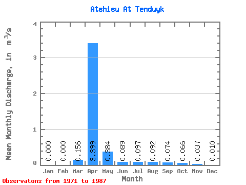
| Statistic | Jan | Feb | Mar | Apr | May | Jun | Jul | Aug | Sep | Oct | Nov | Dec | Annual |
|---|---|---|---|---|---|---|---|---|---|---|---|---|---|
| Mean | 0.00 | 0.00 | 0.16 | 3.40 | 0.38 | 0.09 | 0.10 | 0.09 | 0.07 | 0.07 | 0.04 | 0.01 | 0.19 |
| Standard Deviation | 0.33 | 4.21 | 0.52 | 0.06 | 0.07 | 0.07 | 0.04 | 0.04 | 0.04 | 0.02 | |||
| Min | 0.00 | 0.00 | 0.00 | 0.11 | 0.04 | 0.03 | 0.02 | 0.02 | 0.02 | 0.02 | 0.00 | 0.00 | 0.19 |
| Max | 0.00 | 0.00 | 0.90 | 12.00 | 1.66 | 0.24 | 0.24 | 0.30 | 0.14 | 0.18 | 0.16 | 0.05 | 0.19 |
| Coefficient of Variation | 2.11 | 1.24 | 1.35 | 0.64 | 0.69 | 0.75 | 0.47 | 0.56 | 1.03 | 1.77 |
 Return to R-Arctic Net Home Page