|
|
|||||||||||||||||
| Point ID: 6998 | Downloads | Plots | Site Data | Code: 11250 |
|
|
|||||||||||||||||
| Download | |
|---|---|
| Site Descriptor Information | Site Time Series Data |
| Link to all available data | |
| View: | Time Series | All |
| Units: | mm |
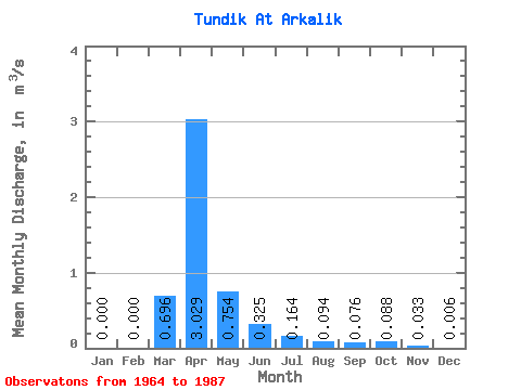
| Statistic | Jan | Feb | Mar | Apr | May | Jun | Jul | Aug | Sep | Oct | Nov | Dec | Annual |
|---|---|---|---|---|---|---|---|---|---|---|---|---|---|
| Mean | 0.00 | 0.00 | 0.70 | 3.03 | 0.75 | 0.33 | 0.16 | 0.09 | 0.08 | 0.09 | 0.03 | 0.01 | 0.29 |
| Standard Deviation | 0.00 | 0.00 | 1.30 | 4.58 | 0.70 | 0.26 | 0.15 | 0.12 | 0.08 | 0.06 | 0.04 | 0.01 | 0.09 |
| Min | 0.00 | 0.00 | 0.00 | 0.29 | 0.10 | 0.02 | 0.00 | 0.01 | 0.01 | 0.00 | 0.00 | 0.00 | 0.22 |
| Max | 0.00 | 0.00 | 4.14 | 22.20 | 3.28 | 1.04 | 0.56 | 0.46 | 0.30 | 0.22 | 0.19 | 0.02 | 0.35 |
| Coefficient of Variation | 1.86 | 1.51 | 0.93 | 0.80 | 0.94 | 1.24 | 1.01 | 0.73 | 1.29 | 1.78 | 0.32 |
 Return to R-Arctic Net Home Page