|
|
|||||||||||||||||
| Point ID: 6989 | Downloads | Plots | Site Data | Code: 11219 |
|
|
|||||||||||||||||
| Download | |
|---|---|
| Site Descriptor Information | Site Time Series Data |
| Link to all available data | |
| View: | Time Series | All |
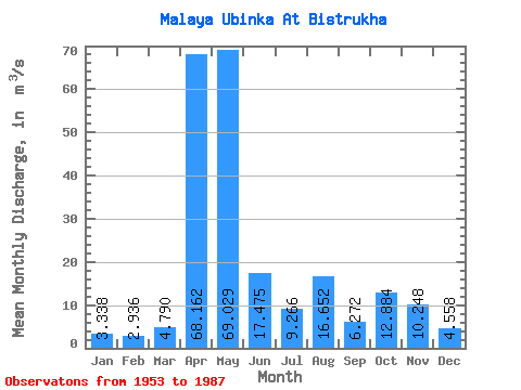
| Units: | mm |
| Statistic | Jan | Feb | Mar | Apr | May | Jun | Jul | Aug | Sep | Oct | Nov | Dec | Annual |
|---|---|---|---|---|---|---|---|---|---|---|---|---|---|
| Mean | 3.34 | 2.94 | 4.79 | 68.16 | 69.03 | 17.48 | 9.27 | 16.65 | 6.27 | 12.88 | 10.25 | 4.56 | 18.81 |
| Standard Deviation | 0.89 | 0.71 | 3.33 | 19.16 | 36.43 | 13.30 | 6.68 | 55.76 | 3.58 | 9.08 | 4.95 | 1.35 | 5.99 |
| Min | 2.28 | 1.46 | 1.95 | 33.70 | 16.30 | 4.94 | 2.41 | 2.26 | 2.18 | 3.99 | 2.99 | 2.33 | 11.24 |
| Max | 5.68 | 4.98 | 20.20 | 102.00 | 146.00 | 63.50 | 31.10 | 331.00 | 19.70 | 45.50 | 19.80 | 7.34 | 39.28 |
| Coefficient of Variation | 0.27 | 0.24 | 0.70 | 0.28 | 0.53 | 0.76 | 0.72 | 3.35 | 0.57 | 0.70 | 0.48 | 0.30 | 0.32 |
 Return to R-Arctic Net Home Page