|
|
|||||||||||||||||
| Point ID: 6983 | Downloads | Plots | Site Data | Code: 11159 |
|
|
|||||||||||||||||
| Download | |
|---|---|
| Site Descriptor Information | Site Time Series Data |
| Link to all available data | |
| View: | Time Series | All |
| Units: | mm |
| Statistic | Jan | Feb | Mar | Apr | May | Jun | Jul | Aug | Sep | Oct | Nov | Dec | Annual |
|---|---|---|---|---|---|---|---|---|---|---|---|---|---|
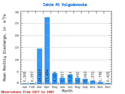
| Mean | 0.31 | 0.40 | 14.61 | 27.49 | 4.50 | 2.56 | 3.81 | 2.49 | 2.06 | 1.37 | 0.80 | 0.43 | 4.68 |
| Standard Deviation | 0.41 | 0.54 | 13.76 | 27.33 | 6.21 | 1.08 | 2.21 | 1.89 | 2.01 | 1.98 | 0.93 | 0.66 | 3.53 |
| Min | 0.06 | 0.00 | 0.19 | 0.41 | 0.56 | 0.98 | 0.92 | 0.25 | 0.29 | 0.26 | 0.14 | 0.02 | 0.98 |
| Max | 1.20 | 1.33 | 34.20 | 63.10 | 20.40 | 4.10 | 7.13 | 7.02 | 7.06 | 7.06 | 3.07 | 2.05 | 8.20 |
| Coefficient of Variation | 1.32 | 1.36 | 0.94 | 0.99 | 1.38 | 0.42 | 0.58 | 0.76 | 0.97 | 1.45 | 1.17 | 1.54 | 0.76 |
 Return to R-Arctic Net Home Page