|
|
|||||||||||||||||
| Point ID: 6982 | Downloads | Plots | Site Data | Code: 11158 |
|
|
|||||||||||||||||
| Download | |
|---|---|
| Site Descriptor Information | Site Time Series Data |
| Link to all available data | |
| View: | Time Series | All |
| Units: | mm |
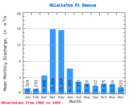
| Statistic | Jan | Feb | Mar | Apr | May | Jun | Jul | Aug | Sep | Oct | Nov | Dec | Annual |
|---|---|---|---|---|---|---|---|---|---|---|---|---|---|
| Mean | 1.32 | 1.23 | 4.45 | 15.86 | 15.65 | 6.18 | 2.98 | 2.42 | 1.91 | 2.42 | 2.32 | 1.62 | 4.85 |
| Standard Deviation | 0.55 | 0.58 | 4.34 | 9.67 | 11.94 | 4.30 | 2.02 | 2.68 | 1.11 | 1.41 | 1.14 | 0.86 | 2.48 |
| Min | 0.76 | 0.29 | 1.34 | 4.00 | 4.29 | 0.90 | 0.47 | 0.41 | 0.55 | 0.98 | 0.83 | 0.53 | 1.82 |
| Max | 2.93 | 2.44 | 20.30 | 43.00 | 50.50 | 15.00 | 7.09 | 13.00 | 5.47 | 6.61 | 5.73 | 4.28 | 11.43 |
| Coefficient of Variation | 0.42 | 0.47 | 0.98 | 0.61 | 0.76 | 0.70 | 0.68 | 1.11 | 0.58 | 0.58 | 0.49 | 0.53 | 0.51 |
 Return to R-Arctic Net Home Page