|
|
|||||||||||||||||
| Point ID: 698 | Downloads | Plots | Site Data | Code: 07CE002 |
|
|
|||||||||||||||||
| Download | |
|---|---|
| Site Descriptor Information | Site Time Series Data |
| Link to all available data | |
| View: | Time Series | All |
| Units: | mm |
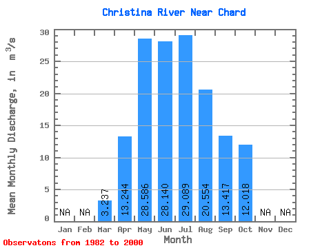
| Statistic | Jan | Feb | Mar | Apr | May | Jun | Jul | Aug | Sep | Oct | Nov | Dec | Annual |
|---|---|---|---|---|---|---|---|---|---|---|---|---|---|
| Mean | 3.24 | 13.24 | 28.59 | 28.14 | 29.09 | 20.55 | 13.42 | 12.02 | |||||
| Standard Deviation | 1.02 | 7.86 | 27.55 | 22.72 | 21.07 | 19.54 | 14.82 | 12.79 | |||||
| Min | 1.74 | 5.18 | 7.01 | 4.58 | 3.85 | 2.23 | 2.79 | 2.68 | |||||
| Max | 5.08 | 35.30 | 95.60 | 76.20 | 76.20 | 78.80 | 61.20 | 50.00 | |||||
| Coefficient of Variation | 0.32 | 0.59 | 0.96 | 0.81 | 0.72 | 0.95 | 1.10 | 1.06 |
 Return to R-Arctic Net Home Page