|
|
|||||||||||||||||
| Point ID: 6964 | Downloads | Plots | Site Data | Code: 11090 |
|
|
|||||||||||||||||
| Download | |
|---|---|
| Site Descriptor Information | Site Time Series Data |
| Link to all available data | |
| View: | Time Series | All |
| Units: | mm |
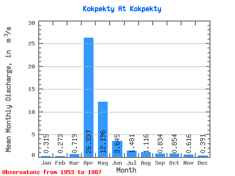
| Statistic | Jan | Feb | Mar | Apr | May | Jun | Jul | Aug | Sep | Oct | Nov | Dec | Annual |
|---|---|---|---|---|---|---|---|---|---|---|---|---|---|
| Mean | 0.32 | 0.27 | 0.72 | 26.34 | 12.20 | 3.65 | 1.48 | 1.12 | 0.83 | 0.85 | 0.62 | 0.39 | 4.40 |
| Standard Deviation | 0.20 | 0.19 | 1.32 | 23.20 | 12.73 | 3.06 | 1.49 | 1.67 | 1.10 | 0.84 | 0.39 | 0.24 | 3.25 |
| Min | 0.05 | 0.03 | 0.05 | 1.95 | 1.61 | 0.67 | 0.20 | 0.18 | 0.25 | 0.26 | 0.14 | 0.01 | 1.05 |
| Max | 0.89 | 0.90 | 5.41 | 79.10 | 61.80 | 14.80 | 6.25 | 7.76 | 6.05 | 4.50 | 1.51 | 1.01 | 13.61 |
| Coefficient of Variation | 0.62 | 0.69 | 1.84 | 0.88 | 1.04 | 0.84 | 1.00 | 1.50 | 1.32 | 0.98 | 0.63 | 0.62 | 0.74 |
 Return to R-Arctic Net Home Page