|
|
|||||||||||||||||
| Point ID: 6962 | Downloads | Plots | Site Data | Code: 11085 |
|
|
|||||||||||||||||
| Download | |
|---|---|
| Site Descriptor Information | Site Time Series Data |
| Link to all available data | |
| View: | Time Series | All |
| Units: | mm |
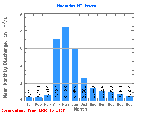
| Statistic | Jan | Feb | Mar | Apr | May | Jun | Jul | Aug | Sep | Oct | Nov | Dec | Annual |
|---|---|---|---|---|---|---|---|---|---|---|---|---|---|
| Mean | 0.49 | 0.41 | 0.61 | 7.12 | 8.42 | 5.96 | 2.56 | 1.45 | 1.12 | 1.05 | 0.85 | 0.52 | 2.43 |
| Standard Deviation | 0.22 | 0.21 | 0.23 | 4.92 | 4.45 | 3.95 | 1.88 | 1.14 | 0.88 | 0.68 | 0.48 | 0.23 | 0.94 |
| Min | 0.14 | 0.07 | 0.26 | 1.78 | 2.23 | 0.87 | 0.07 | 0.04 | 0.15 | 0.29 | 0.18 | 0.02 | 0.94 |
| Max | 1.00 | 1.02 | 1.24 | 23.70 | 18.20 | 18.40 | 7.10 | 5.06 | 4.39 | 3.85 | 2.64 | 0.94 | 4.31 |
| Coefficient of Variation | 0.44 | 0.52 | 0.38 | 0.69 | 0.53 | 0.66 | 0.73 | 0.79 | 0.78 | 0.65 | 0.56 | 0.44 | 0.39 |
 Return to R-Arctic Net Home Page