|
|
|||||||||||||||||
| Point ID: 6920 | Downloads | Plots | Site Data | Code: 10584 |
|
|
|||||||||||||||||
| Download | |
|---|---|
| Site Descriptor Information | Site Time Series Data |
| Link to all available data | |
| View: | Time Series | All |
| Units: | mm |
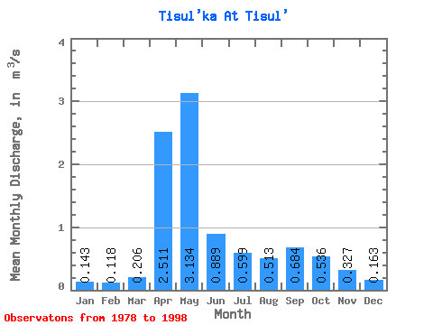
| Statistic | Jan | Feb | Mar | Apr | May | Jun | Jul | Aug | Sep | Oct | Nov | Dec | Annual |
|---|---|---|---|---|---|---|---|---|---|---|---|---|---|
| Mean | 0.14 | 0.12 | 0.21 | 2.51 | 3.13 | 0.89 | 0.60 | 0.51 | 0.68 | 0.54 | 0.33 | 0.16 | 0.81 |
| Standard Deviation | 0.06 | 0.06 | 0.14 | 1.05 | 1.35 | 0.54 | 0.44 | 0.27 | 0.30 | 0.24 | 0.16 | 0.05 | 0.25 |
| Min | 0.05 | 0.03 | 0.08 | 0.81 | 0.79 | 0.26 | 0.21 | 0.18 | 0.20 | 0.22 | 0.15 | 0.06 | 0.37 |
| Max | 0.27 | 0.21 | 0.54 | 4.44 | 5.47 | 2.02 | 1.55 | 0.96 | 1.16 | 1.12 | 0.70 | 0.23 | 1.42 |
| Coefficient of Variation | 0.39 | 0.52 | 0.69 | 0.42 | 0.43 | 0.60 | 0.73 | 0.52 | 0.44 | 0.44 | 0.50 | 0.32 | 0.31 |
 Return to R-Arctic Net Home Page