|
|
|||||||||||||||||
| Point ID: 6902 | Downloads | Plots | Site Data | Code: 10559 |
|
|
|||||||||||||||||
| Download | |
|---|---|
| Site Descriptor Information | Site Time Series Data |
| Link to all available data | |
| View: | Time Series | All |
| Units: | mm |
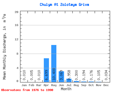
| Statistic | Jan | Feb | Mar | Apr | May | Jun | Jul | Aug | Sep | Oct | Nov | Dec | Annual |
|---|---|---|---|---|---|---|---|---|---|---|---|---|---|
| Mean | 0.01 | 0.01 | 0.01 | 6.70 | 10.40 | 3.07 | 0.96 | 0.30 | 0.19 | 0.18 | 0.10 | 0.03 | 2.69 |
| Standard Deviation | 0.02 | 0.01 | 0.02 | 5.71 | 16.80 | 5.75 | 1.84 | 0.48 | 0.31 | 0.29 | 0.20 | 0.05 | 3.63 |
| Min | 0.00 | 0.00 | 0.00 | 1.71 | 0.40 | 0.02 | 0.01 | 0.02 | 0.01 | 0.01 | 0.01 | 0.00 | 0.25 |
| Max | 0.05 | 0.02 | 0.04 | 17.90 | 60.60 | 20.40 | 6.40 | 1.69 | 0.97 | 1.01 | 0.72 | 0.19 | 9.02 |
| Coefficient of Variation | 1.63 | 1.77 | 1.76 | 0.85 | 1.61 | 1.87 | 1.92 | 1.61 | 1.61 | 1.67 | 1.92 | 1.58 | 1.35 |
 Return to R-Arctic Net Home Page