|
|
|||||||||||||||||
| Point ID: 69 | Downloads | Plots | Site Data | Code: 05AC024 |
|
|
|||||||||||||||||
| Download | |
|---|---|
| Site Descriptor Information | Site Time Series Data |
| Link to all available data | |
| View: | Time Series | All |
| Units: | mm |
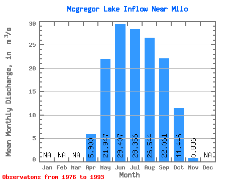
| Statistic | Jan | Feb | Mar | Apr | May | Jun | Jul | Aug | Sep | Oct | Nov | Dec | Annual |
|---|---|---|---|---|---|---|---|---|---|---|---|---|---|
| Mean | 5.90 | 21.95 | 29.41 | 28.36 | 26.54 | 22.06 | 11.45 | 0.84 | |||||
| Standard Deviation | 7.60 | 6.41 | 6.37 | 4.57 | 4.78 | 7.95 | 10.16 | 2.26 | |||||
| Min | 0.00 | 9.15 | 7.33 | 15.40 | 15.00 | 6.76 | 0.03 | 0.00 | |||||
| Max | 24.60 | 29.20 | 34.50 | 33.80 | 32.80 | 33.50 | 28.70 | 8.66 | |||||
| Coefficient of Variation | 1.29 | 0.29 | 0.22 | 0.16 | 0.18 | 0.36 | 0.89 | 2.71 |
 Return to R-Arctic Net Home Page