|
|
|||||||||||||||||
| Point ID: 6894 | Downloads | Plots | Site Data | Code: 10548 |
|
|
|||||||||||||||||
| Download | |
|---|---|
| Site Descriptor Information | Site Time Series Data |
| Link to all available data | |
| View: | Time Series | All |
| Units: | mm |
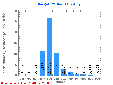
| Statistic | Jan | Feb | Mar | Apr | May | Jun | Jul | Aug | Sep | Oct | Nov | Dec | Annual |
|---|---|---|---|---|---|---|---|---|---|---|---|---|---|
| Mean | 0.09 | 0.07 | 0.07 | 11.19 | 26.47 | 10.27 | 2.99 | 1.58 | 1.07 | 0.87 | 0.62 | 0.18 | 5.11 |
| Standard Deviation | 0.14 | 0.11 | 0.09 | 9.63 | 28.80 | 15.32 | 6.01 | 3.64 | 2.60 | 1.89 | 1.28 | 0.30 | 5.06 |
| Min | 0.00 | 0.00 | 0.00 | 1.02 | 0.33 | 0.03 | 0.00 | 0.01 | 0.01 | 0.01 | 0.01 | 0.01 | 0.43 |
| Max | 0.94 | 0.68 | 0.42 | 45.30 | 126.00 | 69.50 | 28.90 | 19.80 | 15.50 | 9.69 | 6.33 | 1.91 | 23.84 |
| Coefficient of Variation | 1.64 | 1.58 | 1.24 | 0.86 | 1.09 | 1.49 | 2.01 | 2.31 | 2.43 | 2.17 | 2.05 | 1.65 | 0.99 |
 Return to R-Arctic Net Home Page